– Quite An Experience – By Dick Brodeur Our VP-26 PBM squadron was destined to start flying our planes cross country to California and eventually to Pahu, in early September, 1944. We had the opportunity to practice our navigation flights in strange territory when on August 1, 1944 we were ordered to fly PBM-3D BuNo
– Quite An Experience –
By Dick Brodeur
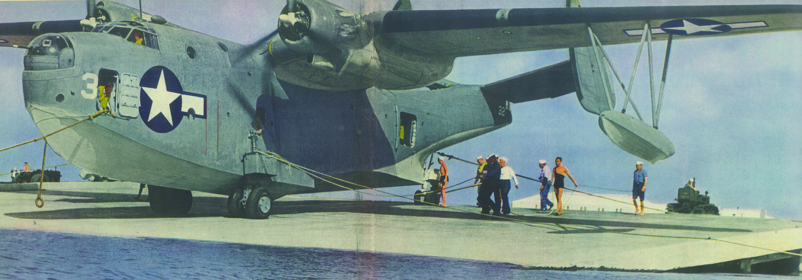
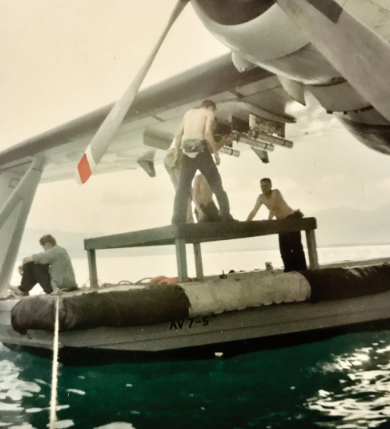
 Our VP-26 PBM squadron was destined to start flying our planes cross country to California and eventually to Pahu, in early September, 1944. We had the opportunity to practice our navigation flights in strange territory when on August 1, 1944 we were ordered to fly PBM-3D BuNo 45322 from Charleston to the waters off Floyd Bennet Field in New York, to escape a hurricane which was moving up the east coast at a rapid rate. It was near dusk when we took off from the Cooper River and headed north. We were flying in the murky weather in the leading edge of the hurricane. In many instances, we were flying just above the shoreline and over the heads of people at the beach watching the surf. I often wondered what they thought, seeing those awkward looking planes flying in such bad weather. We landed in the waters off Floyd Bennet after dark. The nearly five hour flight had come to a successful end with a perfect landing on the swift moving water by Commander Don Coy. We tied to a buoy and remained there until our return flight on August 3, 1944.
The time had come for our deployment to the west coast. Fueled to capacity and with a crew of three pilots and seven aircrewmen, we lifted from the waters of the Cooper River, Naval Air Station, Charleston, South Carolina and headed west for the great state of Texas. The over land route for the flying boat brought us in proximity of any pond, river or lake close to our flight path. This would provide us with water on which to land, in the event an emergency landing was necessary. After about eight hours in the air, we reached our destination, Eagle Mountain Lake, Texas. The lake wasn’t the largest we could hope for but with Commander Coy’s flying expertise, our PBM-3D was brought in for another perfect landing.
I had the duty that night and remember walking the ramp area with a rather vicious looking dog some crew had brought along. Because of squadron aircraft on the ramp, I was instructed to ask any cars parked on the ramp, to leave. These were station personnel who didn’t question the order and departed. The balance of our stay at Eagle Mountain Lake was uneventful.
The next leg of our cross country journey, on September 8, 1944, would bring us from Texas to the southern tip of California. Commander Coy had no problems becoming airborne in the relatively cramped surface of Eagle Mountain Lake, Texas. The PBM, being limited, due to a slow rate of climb, to an operating altitude of 12000 feet or less, crossed the mountain range flying through Guadalupe Pass along with many other aircraft including commercial airline planes. It was something to see the towering mountain ranges on either side of our plane. Another sight I remember during the Texas to California flight was the huge cross on top of the mountain, just out of EI Paso. We learned later, it was the destination for many pilgrimages from the El Paso area.
After being airborne for a little over seven hours, we made our approach to San Diego harbor. Our primary concern was the heavy fog bank that was rolling in from the ocean. As we landed and taxied to the nearest buoy, the fog bank rolled in over us and visibility dropped to zero. What a feeling, something I had never experienced in hometown New Hampshire. There we were, captives of San Diego weather for the next two days. The worse part, we had the watch aboard the fog bound floating flying boat during our stay in San Diego harbor. The fog was so thick, we couldn’t see the city. We communicated with the tower for food and water.
The last leg of our cross country flight took place on September 10, 1944 when we departed the waters of San Diego Bay and headed up the coast, our destination NAS Alameda, California which is located just above San Francisco. We flew along the coast of that beautiful part of the country. We reached our destination in just under four hours. One of our planes wasn’t as lucky as they were forced to make an emergency landing in Monterey Bay. Following repairs, they joined the squadron at Alameda. Alameda was the stop over for crews coming cross country and for those arriving from overseas. With its proximity to San Francisco, it is a pleasant stop before moving on.
The time for the long, trans Pacific flight to Oahu was rapidly approaching. On September 26, 1944 our plane was loaded to capacity with wing tanks and all that goes with it, for our navigation test flight overseas. The after darkness flight was of nearly twelve hours duration as we headed out into the Pacific, reached a pre-determined mid way point and retumed to Alameda. The test went well and it was a good practice run for our celestial navigation and general operations of the plane.
The final leg of our long cross country adventure was from Alameda to Kaneohe Bay, Oahu., a distance of 2100 miles over open water. Our PBM-3D BuNo 45338 was once again fueled to capacity in addition to provisions for the welfare of the crew which consisted of 3 pilots and 5 aircrewmen. On September 28, 1944 we departed the waters of NAS Alameda and set our course for Hawaii. We were told that weather ships were stationed every 500 miles in the event we had to make an emergency landing. We never spotted a single ship from the flight path we followed across the Pacific. At midpoint of our flight path was reached what was called “Jones Comer” and at that point made a two degree turn to port to correct for the curvature of the earth. In spite of being a bit nervous about the accuracy of my navigation, Cdr Coy followed the directions. At the end of the 16.3 hours of flight, Hawaii lay dead ahead. We had made it. It was indeed a pleasure to go ashore at Kaneohe Bay and meet many of our squadron who had made the exciting flight ahead of us. One crew we were told missed Oahu by some 90 miles, thus Cdr Coy’s concerns back at Jones Corner were justified.
Our training continued for what lay ahead. We had comfortable quarters at NAS Kaneohe and plenty of liberty in Honolulu. What more could you ask for.
Reprint from Mariner/Marlin
Association Newsletter,
Jun 2002.

2 Comments
Reg Thatcher
August 24, 2014, 08:56I enjoyed the cross country story of the PBM seaplane from Charleston to Kaneohe
REPLYBay. I was in the Navy at the tail end of WWII as an ETM3C and Radioman aboard the USS Okaloosa (APA219). Unfortunately I did not become a Seaplane Pilot until later,
holding FAA Certificate #2152439 Private Pilot Airplane Single Engine Land and Sea.
Also hold a Celestial Navigators certificate and may be interested in joining your organization if I qualify. Reg Thatcher
Doug
May 30, 2015, 17:01Reg
REPLYI see that you have an interest in seaplanes, that is now all it takes to become a
member. We look forward to seeing you signup, the info is on our website.
Doug